nuffnang leaderboard

Saturday, December 12, 2009

Astro eyes one million users for HD service


KUALA LUMPUR: Pay-TV operator Astro All Asia Networks plc is targeting one million household subscribers for its newly-launched Astro B.yond, a multi-phased innovative service, starting with the country’s first high-definition (HD) broadcast.

“Our target is 30% of our customer base, which is expected to reach three million by year-end.

“We should be able to secure at least half of the one million in the next 12 to 18 months,” said Astro TV chief executive officer Datuk Rohana Rozhan after the launch of Astro B.yond yesterday.

At 48% penetration of Malaysian TV homes, Astro is currently streaming to 2.875 million homes.


From left: Astro TV chief technology officer Paul Dale, Datuk Rohana Rozhan and chief operating officer Henry Tan at the Astro B.yond launch.

Rohana said about 1.2 million of Astro’s customers were HD-ready, adding that according to an industry report, 59% of all televisions sold in the first half of this year were HD-ready and sales in this segment were growing.

“All data indicate that Astro’s introduction of HD service comes at an opportune time and the market is ready for HD content,” she said.

Rohana said the investment in HD broadcast technology and related services would fall under the company’s capital expenditure (capex) and operating expenditure (opex).

“Our capex and opex for the financial year ending Jan 31, 2010 (FY10) are RM100mil each while RM200mil and RM150mil have been allocated for capex and opex respectively in FY11,” she said.

She added that the capex and opex would come from the company’s internal fund.

On Astro B.yond, Rohana said it offered customers more innovative services which would be introduced in phases. Customers can sign up for Astro B.yond and access to HD services for an additional RM20 per month for a 12-month period. They will receive a new B.yond box, new smart card, new outdoor dish, HD multimedia interface cable and new remote control.

New set-up installation fee will be waived in exchange for the existing box.

HDTV offers viewers an enhanced entertainment experience with better quality images in true definition details, cinematic surround sound, vibrant colours, wider screen and about five times the detail of standard definition TV.

Rohana said Astro would kick off Astro B.yond with three key genres that were recognised as HD content drivers globally – sports, movies and documentaries.

Astro Supersport HD, HBO HD, National Geographic Channel HD and History HD will start screening on Dec 18, followed by ESPN HD next month.

It plans to launch another five HD channels next year.

Over the next 24 months, Astro B.yond will introduce an intuitive electronic programming guide, digital video recording, video on demand and Internet protocol TV connectivity.

Tuesday, November 10, 2009

Track anything


ATS Automobile has launched a GPS device for keeping track of your valuable ­possessions.
MyNav GPS Tracker is one of the smallest tracking devices, making it easy to attach to any surface or object, according to Kithsiri Kumar, the company’s director.

The device works by using a combination of three technologies — GSM, GPRS and GPS. It can send out an SMS alert with its current location and moving speed if it is in transit.

And when the tracker is not able to achieve a GPS lock, it would still be able to roughly triangulate its position using cell towers.


“Up take of the device has been good as people are considering personal tracking devices as an additional security measure for valuable assets such as cars,” he said.


To date the company has sold over 200 units of the device over the course of three months, said Kithsiri.


The tracker can also be used as a personal security device for children as it also comes with a panic button. Pressing this button will make the device send out an SMS every three seconds.

Other uses include voice surveillance as it allows users to call the device and listen in on what’s going on via the tracker’s built-in microphone.


ATS Automobile says the MyNav GPS Tracker is able to last up to one week or 50 hours of continuous usage on a single charge.


The tracker would also alert the user via SMS if it’s running out of power.
MyNav GPS Tracker retails for RM899. — CHONG JINN XIUNG


Saturday, November 7, 2009

Sony Ericsson Droid Phone

Sony Ericsson today announced its Xperia X10 smartphone, based on Android, which features a customized software layer called UX built on top of the open-source operating system. It’s the first of a family of smartphones that the company plans to deliver in the first half of next year, and won’t be available until then. While it has some high-end features that could help it compete with the much-hyped Droid, unlike Motorola’s and Verizon’s handset, this phone has a surprising shortcoming.
The Xperia X10 — even though it won’t ship until next quarter — will run Android 1.6. The Droid runs Android 2.0, which has a slew of advanced features and is shipping this month. In fact, most of the Droid’s substantial marketing campaign is built around new features in Android 2.0.
The X10 also has a 1-GHz Qualcomm Snapdragon chip, which many of the newer Android-based smartphones are moving to, and the iPhone runs. While the Droid phone has a 5-megapixel camera, the Xperia X10’s is 8.1 megapixels with video recording and 16x digital zoom. jkOnTheRun points out some of the other notable features:
4-inch capacitive touchscreen at 854 x 480 resolution
Android 1.6
1GB of internal memory, 8GB of included microSD storage
GPS, Wi-Fi, stereo Bluetooth
Quad-band GSM and two flavors of HSPA support, depending on model (UMTS HSPA 900/1700/2100 or UMTS HSPA 800/1900/2100)
The Xperia X10 will run applications from both the Android Market and Sony Ericsson’s PlayNow Arena. There is no price available yet, but it already looks like this phone will have a tough time competing unless it sees an upgrade to Android 2.0 as it goes to market.

Saturday, October 3, 2009

New GPS Service Free, More Accurate in Europe

New GPS Service Free, More Accurate in Europe
Daniel Ionescu

Oct 2, 2009 10:28 pm


The European Union introduced on Thursday a free global positioning system that it claims is almost five times more accurate than the U.S. system currently in use.
Called the European Geostationary Navigation Overlay Service (EGNOS), the system uses three satellites and a ground network of about 40 ground positioning stations and four control centers.

The U.S. military-run GPS system, in widespread use across the globe, offers a 10-meter (32 feet) accuracy level, but EGNOS promises to fine-tune this experience and deliver accuracy levels to around 2 meters (6 feet).

EGNOS only covers the 27 member-states of the EU at the moment, but it is expected to expand to neighbouring nations and Northern Africa in the near future. The service is free for use by anyone within the coverage area with a GPS/SBAS compatible receiver.

The EU sees various uses for its more-accurate GPS system, which was in testing mode since 2006. Farmers would benefit from precision spraying fertilizers, and blind people could have personal guides. It could automatically charge road tolls or pay-per-use car insurance.

It is also expected that the next generation of GPS-enabled smarptohones such as the Apple iPhone, Palm Pre or Google Android devices, will benefit from the improved accuracy of EGNOS. Some standalone GPS devices might soon use EGNOS as well, given that the manufacturers release firmware updates to support the system.

EGNOS is mainly the precursor of EU's Galileo project, Europe's own GPS system, which has been plagued with delays in the last years and is expected to begin operating in 2014.

Meanwhile, American users have had their EGNOS equivalent for some tine now, called Wide Area Augmentation Service (WAAS) and the Japanese are working on a similar system called Multi-Functional Satellite Augmentation System (MFAS).

Wednesday, September 2, 2009

Assisted GPS

From Wikipedia, the free encyclopedia

Assisted GPS, generally abbreviated as A-GPS, is a carrier network dependent system which can, under certain conditions, improve the startup performance of a GPS satellite-based positioning system. It is used extensively with GPS-capable cellular phones as its development was accelerated by the U.S. FCC's 911 mandate making the location of a cell phone available to emergency call dispatchers.[1]

Conventional or "Standalone GPS" operation uses radio signals from satellites. In very poor signal conditions, for example in a city these signals may suffer multipath where signals bounce confusingly off buildings, or be weakened by passing through walls or tree cover. When first turned on in these conditions, some non-assisted GPS navigation device may not be able to work out a position due to the fragmentary signal, rendering them unable to function until a clear signal can be received continuously for up to 40 seconds. (the time needed to download the GPS ephemeris.) Some newer receivers are better at handling these situations.
An A-GPS system can address these problems in several ways, using an assistance server or other data from a network.

Assistance falls into two categories:

Using information known to the assistance server but not the phone.
It can supply orbital data and/or almanac for the GPS satellites to the cell phone, enabling the cell phone to lock to the satellites faster in some cases.
The network can provide atomic time (Accurate Time Assistance)
The device capturing a snapshot of the GPS signal, with approximate time, for the server to later process into a position.[2]

Accurate, surveyed coordinates for the cell site towers allow better knowledge of local ionospheric conditions and other errors affecting the GPS signal than the cell phone alone, enabling more precise calculation of position. (See also Wide Area Augmentation System)
Calculation of position by the server using information from the phone.

The assistance server has a good satellite signal, and plentiful computation power, so it can compare fragmentary signals relayed to it by cell phones, with the satellite signal it receives directly, and then inform the cell phone or emergency services of the cell phone's position.

As an additional benefit, in certain types of A-GPS, both the amount of CPU and programming required for a GPS phone is reduced by offloading most of the work onto the assistance server. (This is not a large amount for a basic GPS – many early GPSs utilized Intel 80386-class 16 MHz CPUs or similar hardware.)

A typical A-GPS-enabled cell phone will use a data connection (internet, or other) to contact the assistance server for A-GPS information. If it also has functioning autonomous or standalone GPS, it may use standard GPS, which is sometimes slower on Time To First Fix, but does not lead to network dependent downsides, such as failure to work outside of network range, or charges for data traffic.[3] Some A-GPS solutions do not have the option of falling back to standalone or autonomous GPS.

High Sensitivity GPS is an allied technology that addresses some of the same issues in a way that does not require additional infrastructure. However, unlike some forms of A-GPS, high sensitivity GPS cannot provide instant fixes when the phone has been off for some time.

Drawbacks

Some A-GPS devices lack standalone GPS capability. They may not function at all unless the device has an active subscription to a network, and is in range of that network. Others offer additional Local Positioning Systems and use whatever ones are available at the moment. Conventional GPS receivers are only limited in the opposite sense, offering service whenever good GPS signals are available.

Some A-GPS solutions inherently give the users position very accurately to the assistance server. However, for mobile phones, the privacy concern this represents is somewhat diluted by the fact that the network already knows the position of the phone to within several hundred meters or better.

Link: http://en.wikipedia.org/wiki/Assisted_GPS

Monday, August 24, 2009

HOW GPS WORKS


Brief history

1960: The first ever navigational system – Transit – is launched by the US Navy, and used to accurately locate ballistic missile submarines and ships.

1967: The US Air Force develops the Timation satellite which proved the ability to place accurate clocks in space, a technology that GPS relies upon intensively.

1973: US Navy and Air Force combine their respective navigation systems in an effort to develop a Defence Navigation Satellite System which would later become NAVSTAR GPS.

1978: The first of the experimental GPS Block I satellites is launched (which comprised 10 satellites, the last of which was launched in 1985).

1983: A Korean civilian airliner is shot down by Russian fighters after accidentally intruding into Soviet air space. US president Ronald Reagan subsequently declassified the NAVSTAR GPS system to prevent any such tragedy from happening again, thereby making GPS available to civilians.

1989: The first of the GPS Block II modern satellites is launched.

1990: NAVSTAR GPS becomes operational.

1991: The first Gulf War begins. Although not fully operational at the time, GPS allows the American military to prove the usefulness of the system by obtaining accurate coordinates in the featureless Iraqi desert.

1994: The last of the Block IIA satellites is launched, completing the constellation of 24 GPS satellites.

1995: The Block II NAVSTAR GPS constellation is declared to be fully operational.

2005: The first modernised GPS satellite is launched and begins transmitting a second civilian signal for enhanced user performance. Six more of these are launched between 2005 and 2008, bringing the total number of GPS satellites in orbit to 31.Brief history

For more on GPS please click here:
http://thestar.com.my/lifestyle/story.asp?file=/2009/8/24/lifefocus/3896794&sec=lifefocus
http://thestar.com.my/lifestyle/story.asp?file=/2009/8/24/lifefocus/3896774&sec=lifefocus
http://thestar.com.my/lifestyle/story.asp?file=/2009/8/24/lifefocus/4133569&sec=lifefocus

Garmin and Asus

Garmin and Asus show the way
By TAN KIT HOONG

GPS giant Garmin and hardware maker Asus have teamed up to make a couple of new smartphones under the Nuvifone name.

Nuvifone M20
These so-called “location-centric” mobile phones, the G60 and M20, support HSDPA and come with 4GB of internal storage, 802.11b/g WiFi, Bluetooth and 3-megapixel digital cameras with autofocus.

However, that’s where the similarities between the two phones end — the Nuvifone G60 has a 3.5in touchscreen and runs on the Linux operating system, while the Nuvifone M20 features a 2.8in touchscreen and runs Windows Mobile 6.1 Professional.

Of course the big feature on both Nuvifone models is that they have built-in A-GPS and more importantly, come with Garmin’s popular and user-friendly GPS software.
The Garmin GPS software has a number of new location-based features which Asus claims is unique in smartphones with built-in GPS.

For one thing, the GPS in both phones are meant to be always-on (although it can be turned off) and offer location-based services which are customised depending on your GPS coordinates.

For example, the Nuvifone can give you live currency and weather information based on your current location, as well as remember where you’ve parked (although not in underground car parks where the GPS is unable to get a lock).


Nuvifone G60
Additonally, the 3-megapixel camera on the G60 and M20 supports geotagging and will insert location information into the photo’s JPEG information so that it can be used in applications such as Google Maps and Apple’s iPhoto.

Overall, the emphasis for both phones is slightly different — while the G60 has a more GPS-centric slant with basic phone functions, the M20 has more robust phone features as well as Microsoft Exchange push e-mail support and Office Mobile applications.

The Nuvifone G60 costs RM1,799 and is available now, while the Nuvifone M20 is slated to appear early next month for RM2,099.
++++
http://www.garminasus.com/

Tuesday, July 14, 2009

Father Anthony Chan laid to rest at Holy Catholic Family Cementary Kajang.


Father Anthony Chan laid to rest at Holy Catholic Family Cementary Kajang at about 2.00 pm today.


Father Anthony Chan's last message

Fr Anthony Chan’s 83 birthday celebration Published on May 30 , 2009By Conrad Nunis

KLANG: Fr Anthony Chan’s 83rd birthday celebration was held on April 25. During the celebration, Fr Chan took the opportunity to thank everyone present for all their efforts in organising the event.

During the dinner Fr Chan spoke on his life. “Dear brothers and sisters in Christ, I was born in 1926 in Guangdong Province, China, to a very poor family. My family were devout Catholics and they lived their faith seriously. I too revered God from a young age.

“When I was 20 years old, I walked 12 days to join the junior seminary and began my formal seminary education in Jiangmen. Later, I was sent to Hong Kong to continue my studies.

“I was ordained on July 7, 1956. Immediately after my ordination, I was sent to Malaya (now Malaysia) to serve the Chinese community for there was a lack of Chinese-speaking priests in this country.

When I came to Malaya, I could only speak two dialects, Cantonese and Guangxi. I only learnt to speak Mandarin, English and Bahasa Malaysia while in Malaya.

I started my first missionary work in Terengganu. Fifty years ago, this town was remote and underdeveloped, covered with jungle and barren hills. Life was tough. However, I had to endure all obstacles.

My most memorable encounter was being able to convert and baptize a Buddhist nun. As a priest too, these pastoral experiences gave me even greater strength and determination to continue my missionary work.

“In all my 53 years as a priest in Malaysia, I have served in several towns in Peninsular Malaysia, i.e . Kuala Lumpur, Kuala Terengganu, Kajang, Kuantan, Kuala Kubu Bharu, Rawang, Klang, Port Klang and Pandamaran.

“Since my retirement some years ago, I am enjoying a wonderful and pleasant semiretirement in Klang. The parishioners, be they Chinese speaking, English, Tamil or Malay speaking, love me and take good care of me. They ensure my needs are taken care
of and also my birthday is celebrated every year without fail.

“A group of Chinese parishioners knew I had a desire to return to my hometown in my remaining years. They planned and accompanied me to visit my 87-year old brother and his family, my relatives and friends. I took this opportunity to visit the Jiangmen Junior Seminary.

“For the first time in my entire priesthood, this was my first time celebrating Mass in my ancestors’ home with the assistance of the local priest, Wong Fei. This blessed occasion was very unique, as more than 100 people attended this Eucharistic celebration.

Another surprising incident was that when I was celebrating Mass in Zhan Jiang, the local Bishop Su Yong Da of Zhan Jiang became my altar server. I was humbled, yet honoured by this gesture.

“As many of you are aware, I have not been well lately. My illness has relapsed but I’m not complaining. I know that God is in it and I will embrace His decision. I ask for your prayers to accept His will.”

His parting advice to his parishioners was to read the Bible daily and pray earnestly for more vocations and make prayer part of our lives. —

Source: http://www.heraldmalaysia.com/news/storydetails.php/953-1-2-Fr-Anthony-Chan-s-83-birthday-celebration

FAREWELL TO REV. FR. ANTHONY CHAN


Thursday, July 2, 2009

One for the road


Garmin Mobile PC software brings navigation to your PC for a reasonable price but with some drawbacks.
SIMPLE SET UP: Garmin Mobile GPS on a mini notebook with a Bluetooth GPS receiver.
With the popularity of Intel Atom-based mini notebooks that last five to six hours on a single charge, I recently started thinking about another possible use for it — as a GPS navigation device.
Of course, since no mini notebook currently on the market has built-in GPS, you can’t just get an out-of-the-box experience with it — for one, you need at least an external GPS unit which connects to your mini notebook via USB or Bluetooth.
If you already have a Garmin Bluetooth or USB GPS receiver, then you can use that, but the good thing is that Mobile PC isn’t limited to Garmin-branded GPS receivers.
The software works with all third party GPS units, but with one limitation. We’ll talk about this later.
The other requirement is that you have to download a local map. You can download one from www.malsingmaps.com, which has a free map that was last updated on February 2008.
The regularly updated maps are only available if you actively contribute to the website’s mapping effort.
By the way, there are shops in Kuala Lumpur which sell the software but it is a little cheaper if you buy from an online site like www.semsons.com/garmin.html.
Installation
If you have a notebook or mini notebook running Windows XP or Vista (with at least an 800 x 600pixel resolution) then the installation is pretty simple — just pop the supplied CD into an optical drive and install the software.
Once installed, you have to first connect your GPS (in my case using Bluetooth) and pair up the device with the notebook.
Once paired, start up Mobile PC and follow the steps to get the GPS working with the software.
Oh yes, here’s the limitation — if you’re using a Bluetooth or USB GPS unit that isn’t made by Garmin, the Mobile PC will be activated and tied to only the machine you install it on and will not accept activation on another machine.
However, if you have the Garmin GPS 10x or GPS 20x then the software instead looks for the unique identifier within the receiver and allows you to install the ­software on any machine, as long as you use the same Garmin receiver with the software.
Using the software
So now we get right down to the important bit — just how does Mobile PC perform for navigation?
Well, quite well actually and if you’re familiar with Nuvi series, the software is pretty much the same, presenting you with a very ­user-friendly “Where To?” and “View Map” options on the front page.
View Map is self-explanatory and brings you to a 3D view of the current map, with a little button on the bottom left hand corner that will switch to the flat 2D view with more detail.
UNIQUE: The 3D map interface in Garmin Mobile PC is where all navigation happens. If you don't like the 3D interface, you can still opt for the traditional 2D view.
Whether it’s the 2D or 3D view, you can zoom in and out of the map, although scrolling and ­changing orientation is only allowed in 2D view.
By the way, Mobile PC works with any notebook PC running Windows, and will work especially well with Tablet PCs, although it works with the touchpad and keyboard to navigate the interface as well.
“Where To?” is the ­starting point of all your navigation needs and will bring you to a list of icons — most notably, the “Home,” “Food, Hotels...” and “Favourites” icons.
Home, of course, is to navigate back to your home, and can be set the first time you click on the Home icon based on your current location or if you have the specific ­coordinates for your home.
Favourites is where you store your custom waypoints for easy navigation and reference later.
The strange quirk of the Malsingmaps and Mobile PC, ­however (and I hear this is a problem also in the Nuvi series) is that if you want to search for an address you have to click on “Where To?”, then click on, say, “Food, Hotels...” instead of Addresses ­directly.
For some strange reason, if you instead click on Addresses under the “Where To?” menu, you can only search United States addresses. Don’t ask me why — hopefully, this can be fixed in a later update.
Once your destination is chosen, you get voice prompts with turn-by-turn directions to guide you.
Like certain high-end Garmin Nuvi models, Mobile PC, by default, has a voice synthesiser which will speak the directions and road names in a robotic female voice.
DETAILED: The 2D view gives you a more detailed map for a visual search of points of interest.
The problem is that since Malaysian roads are actually pronounced in a different way from normal English words, the voice synthesiser usually makes such a hash of the road names that I can’t make sense of it.
In the end, I opted for the nice pre-recorded British female voice, which sounds a lot clearer when speaking and instead of saying “In 300m, turn left at Jeh-lan Kay-uh Air-Ay” (“Turn left at Jalan Kayu Ara”) it says “Turn left in 300m.”
Oh yes, if you have an Internet connection on the notebook, you also have access to some special Garmin online features, namely checking the weather in your local area, as well as checking ­international flights.
You get more features, however, if you are in the United States.
There are loads of other features as well, but the most notable one not directly connected with ­navigation is the Trip Computer, which gives you a car dashboard-like interface with a speedometer, odometer and other info on your trip, such as driving time, total time travelled (with GPS on), average driving speed and ­maximum speed travelled.
All the information could be useful if you want to keep detailed records of your trip or gauge the fuel consumption of your car.
Notebook issues
Of course, the software is just one aspect of using Mobile PC and the question is just how practical is it to use the software on a mini notebook?
Well, I own the Asus Eee PC 901, which together with the Atom processor and a fairly large battery, has battery life that’s long enough for almost any navigating you need to do in your car, so in terms of battery life, there’s no complaint there.
The one problem I had with using a mini notebook as a navigation device is that it’s still not quite as portable as it could be — unless you have a special stand made for it, you’re not going to be able to put the notebook anywhere where it’s easy for you to glance at.
I could only lay it down on the passenger seat and glance at it occasionally.
Another problem is that using the keyboard to input your destination is not that easy when it’s fairly dark outside.
Oh yes, I have a car stereo with a 3.5mm stereo input so I can connect the stereo output of the notebook to my car stereo so I can hear voice prompts clearly.
However, if you have no such connection on your car stereo, you have to also consider how loud your notebook can go before using Mobile PC.
My Eee PC 901 is actually loud enough to hear without connecting to my car ­stereo, but it’s one of the few notebooks that feature really good speakers.
Conclusion
Based on functionality alone, the Garmin Mobile PC software is excellent — it provides all you need for navigation as well as a few more features found only in high-end Garmin Nuvi devices.
The only problems really arise from the choice of notebook you install it on and whether you get loud enough audio or battery life to justify using it as a navigation tool.
So the answer is yes, Mobile PC is great, but you need to consider the limitations of your notebook before you use it.
Pros: Lots of features; easy-to-use interface; voice navigation; compatibility with Malsingmaps maps.
Cons: Using it on a notebook in dim light can be a bit fiddly.
Garmin Mobile PC
(Garmin Ltd)
GPS navigation software
System requirements: Windows 2000 SP2/XP/Vista, 256MB RAM, 1.3GB HDD space
Features: Garmin Online
Price: US59.90 (RM200)
Website: www.garmin.com

Tuesday, June 30, 2009

Pergola_installation


Pergola installation started in early March 2009. Photos taken but too busy to upload, anyway here the photos.

Saturday, June 27, 2009

Balau Wood Flower Pot Stand


Balau Wood Flower Pot Stand, at RM 7.00 a foot - total twenty feet cost RM 140.00. Actually it from the pergola that Mr. Osman of Farouk Renovations change to a bigger size balau wood. I ask him to cut it a made into stand for flower pot. By the way anyone knows how to prevent insects from attacking my palm leaves plant.

Thursday, June 25, 2009

Pergola with Skylight


My pergola with skylight is finally completed. Actually it is already completed a few months ago, but because the wood is smaller and not suitable. Twenty feet span and it shows sign of curve, and Mr. Osman of Farouk Renovation is now satisfied with it. This time with a bigger sturdier balau wood it look much better. Will take a photo and post it. My pergola with skylight is finally completed. Actually it is already completed a few months ago, but because the wood is smaller and not suitable. Twenty feet span and it shows sign of curve, and Mr. Osman of Farouk Renovation is now satisfied with it. This time with a bigger sturdier balau wood it look much better.


Sunday, June 7, 2009

How to Identify the Product Version?

It is easy to tell nüvi 255W Mal/Sing from other nüvi 255W versions.
In the front side of its package, you will see:
“Dual maps preloaded...” highlighted:Garmin nüvi 255W Mal/Sing is preloaded with Garmin City Navigator & Malsing Maps
Display screen with junction image and lane info Featuring brief descriptions of the latest nüvi 255W features: Junction View & Lane Info


Every Garmin product is assigned with a unique part number.
On the bottom of the package, you can check its part number. And the Garmin part number assigned to nüvi 255W Mal/Sing is 010-00718-69.


Saturday, June 6, 2009

What is GPS?

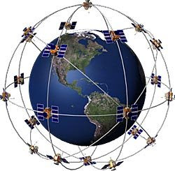
T The GPS Satellite System.


What is GPS?
The Global Positioning System (GPS) is a satellite-based navigation system made up of a network of 24 satellites placed into orbit by the U.S. Department of Defense. GPS was originally intended for military applications, but in the 1980s, the government made the system available for civilian use. GPS works in any weather conditions, anywhere in the world, 24 hours a day. There are no subscription fees or setup charges to use GPS.
How it works
GPS satellites circle the earth twice a day in a very precise orbit and transmit signal information to earth. GPS receivers take this information and use triangulation to calculate the user's exact location. Essentially, the GPS receiver compares the time a signal was transmitted by a satellite with the time it was received. The time difference tells the GPS receiver how far away the satellite is. Now, with distance measurements from a few more satellites, the receiver can determine the user's position and display it on the unit's electronic map.

A GPS receiver must be locked on to the signal of at least three satellites to calculate a 2D position (latitude and longitude) and track movement. With four or more satellites in view, the receiver can determine the user's 3D position (latitude, longitude and altitude). Once the user's position has been determined, the GPS unit can calculate other information, such as speed, bearing, track, trip distance, distance to destination, sunrise and sunset time and more.
How accurate is GPS?
Today's GPS receivers are extremely accurate, thanks to their parallel multi-channel design. Garmin's 12 parallel channel receivers are quick to lock onto satellites when first turned on and they maintain strong locks, even in dense foliage or urban settings with tall buildings. Certain atmospheric factors and other sources of error can affect the accuracy of GPS receivers. Garmin® GPS receivers are accurate to within 15 meters on average.
Newer Garmin GPS receivers with WAAS (Wide Area Augmentation System) capability can improve accuracy to less than three meters on average. No additional equipment or fees are required to take advantage of WAAS. Users can also get better accuracy with Differential GPS (DGPS), which corrects GPS signals to within an average of three to five meters. The U.S. Coast Guard operates the most common DGPS correction service. This system consists of a network of towers that receive GPS signals and transmit a corrected signal by beacon transmitters. In order to get the corrected signal, users must have a differential beacon receiver and beacon antenna in addition to their GPS.


The GPS satellite system
The 24 satellites that make up the GPS space segment are orbiting the earth about 12,000 miles above us. They are constantly moving, making two complete orbits in less than 24 hours. These satellites are travelling at speeds of roughly 7,000 miles an hour.
GPS satellites are powered by solar energy. They have backup batteries onboard to keep them running in the event of a solar eclipse, when there's no solar power. Small rocket boosters on each satellite keep them flying in the correct path.
Here are some other interesting facts about the GPS satellites (also called NAVSTAR, the official U.S. Department of Defense name for GPS):
The first GPS satellite was launched in 1978.
A full constellation of 24 satellites was achieved in 1994.
Each satellite is built to last about 10 years. Replacements are constantly being built and launched into orbit.
A GPS satellite weighs approximately 2,000 pounds and is about 17 feet across with the solar panels extended.
Transmitter power is only 50 watts or less.
What's the signal?
GPS satellites transmit two low power radio signals, designated L1 and L2. Civilian GPS uses the L1 frequency of 1575.42 MHz in the UHF band. The signals travel by line of sight, meaning they will pass through clouds, glass and plastic but will not go through most solid objects such as buildings and mountains.
A GPS signal contains three different bits of information — a pseudorandom code, ephemeris data and almanac data. The pseudorandom code is simply an I.D. code that identifies which satellite is transmitting information. You can view this number on your Garmin GPS unit's satellite page, as it identifies which satellites it's receiving.
Ephemeris data tells the GPS receiver where each GPS satellite should be at any time throughout the day. Each satellite transmits ephemeris data showing the orbital information for that satellite and for every other satellite in the system.
Almanac data, which is constantly transmitted by each satellite, contains important information about the status of the satellite (healthy or unhealthy), current date and time. This part of the signal is essential for determining a position.
Sources of GPS signal errors
Factors that can degrade the GPS signal and thus affect accuracy include the following:
Ionosphere and troposphere delays — The satellite signal slows as it passes through the atmosphere. The GPS system uses a built-in model that calculates an average amount of delay to partially correct for this type of error.
Signal multipath — This occurs when the GPS signal is reflected off objects such as tall buildings or large rock surfaces before it reaches the receiver. This increases the travel time of the signal, thereby causing errors.
Receiver clock errors — A receiver's built-in clock is not as accurate as the atomic clocks onboard the GPS satellites. Therefore, it may have very slight timing errors.
Orbital errors — Also known as ephemeris errors, these are inaccuracies of the satellite's reported location.
Number of satellites visible — The more satellites a GPS receiver can "see," the better the accuracy. Buildings, terrain, electronic interference, or sometimes even dense foliage can block signal reception, causing position errors or possibly no position reading at all. GPS units typically will not work indoors, underwater or underground.
Satellite geometry/shading — This refers to the relative position of the satellites at any given time. Ideal satellite geometry exists when the satellites are located at wide angles relative to each other. Poor geometry results when the satellites are located in a line or in a tight grouping.
Intentional degradation of the satellite signal — Selective Availability (SA) is an intentional degradation of the signal once imposed by the U.S. Department of Defense. SA was intended to prevent military adversaries from using the highly accurate GPS signals. The government turned off SA in May 2000, which significantly improved the accuracy of civilian GPS receivers.
Learn more about GPS
For more detailed information about GPS and how it works, check out our GPS Guide for beginners .

Thursday, June 4, 2009

GPS System 'Close to breakdown'


GPS system 'close to breakdown'
Network of satellites could begin to fail as early as 2010
Comments (…)
Buzz up!
Digg it (22)
Bobbie Johnson, San Francisco
guardian.co.uk, Tuesday 19 May 2009 10.32 BST
Article history
It has become one of the staples of modern, hi-tech life: using satellite navigation tools built into your car or mobile phone to find your way from A to B. But experts have warned that the system may be close to breakdown.
US government officials are concerned that the quality of the Global Positioning System (GPS) could begin to deteriorate as early as next year, resulting in regular blackouts and failures – or even dishing out inaccurate directions to millions of people worldwide.
The warning centres on the network of GPS satellites that constantly orbit the planet and beam signals back to the ground that help pinpoint your position on the Earth's surface.
The satellites are overseen by the US Air Force, which has maintained the GPS network since the early 1990s. According to a study by the US government accountability office (GAO), mismanagement and a lack of investment means that some of the crucial GPS satellites could begin to fail as early as next year.
"It is uncertain whether the Air Force will be able to acquire new satellites in time to maintain current GPS service without interruption," said the report, presented to Congress. "If not, some military operations and some civilian users could be adversely affected."
The report says that Air Force officials have failed to execute the necessary steps to keep the system running smoothly.
Although it is currently spending nearly $2bn (£1.3bn) to bring the 20-year-old system up to date, the GAO – which is the equivalent of Britain's National Audit Office – says that delays and overspending are putting the entire system in jeopardy.
"In recent years, the Air Force has struggled to successfully build GPS satellites within cost and schedule goals," said the report. "It encountered significant technical problems … [and] struggled with a different contractor."
The first replacement GPS satellite was due to launch at the beginning of 2007, but has been delayed several times and is now scheduled to go into orbit in November this year – almost three years late.
The impact on ordinary users could be significant, with millions of satnav users potential victims of bad directions or failed services. There would also be similar side effects on the military, which uses GPS for mapping, reconnaissance and for tracking hostile targets.
Some suggest that it could also have an impact on the proliferation of so-called location applications on mobile handsets – just as applications on the iPhone and other GPS-enabled smartphones are starting to get more popular.
Tom Coates, the head of Yahoo's Fire Eagle system – which lets users share their location data from their mobile – said he was sceptical that US officials would let the system fall into total disrepair because it was important to so many people and companies.
"I'd be surprised if anyone in the US government was actually OK with letting it fail – it's too useful," he told the Guardian.
"It sounds like something that could be very serious in a whole range of areas if it were to actually happen. It probably wouldn't damage many locative services applications now, but potentially it would retard their development and mainstreaming if it were to come to pass."
The failings of GPS could also play into the hands of other countries – including opening the door to Galileo, the European-funded attempt to rival America's satellite navigation system, which is scheduled to start rolling out later next year.
Russia, India and China have developed their own satellite navigation technologies that are currently being expanded.

Junction View - Garmin Nuvi 255W


Yes, wide screen is great for junction view. Just look at the images.

Tuesday, June 2, 2009

Garmin nuvi 255 wide


Yesterday went shopping for GPS devices and bought the 255w instead 205w. The 205w is not available obsolute already. The Garmin nuvi 255 wide only cost RM899 with map of Malaysia and Singapore installed. Bahasa Malaysia and English voice command is installed in the localised version of 255w.


Nüvi® 255W
An Affordable, full-featured Navigation Device.Widescreen and preloaded with West Malaysia and Singapore Maps with Junction View and Lane Assist capability!


Go Beyond Navigation
Navigation is just the beginning. nüvi 255W includes many travel tools including JPEG picture viewer, world travel clock with time zones, currency converter, measurement converter, calculator and more.
What's in the Box:
1x Nüvi 255W 1x Vehicle suction cup mount 1x Vehicle power cable 1x Dashboard disc Quick start manual.


Navigate With Ease
nüvi 255W comes ready to go right out of the box with preloaded West Malaysia and Singapore maps, including a hefty points of interest (POIs) database with hotels, restaurants, fuel, ATMs and more. Simply touch the color screen to enter a destination, and nüvi takes you there with turn-by-turn voice directions, 2-D or 3-D maps and smooth map redraw rates as you navigate. Its digital elevation maps show you shaded contours at higher zoom levels, giving you a big picture of the surrounding terrain. In addition, nüvi 255W accepts custom points of interest (POIs), such as school zones and safety cameras and lets you set proximity alerts to warn you of upcoming POIs.


Thursday, May 28, 2009

GARMIN nuvi 205w


This model is available in Malaysia for RM879.


- 4.3" Wide touch screen display
- Turn-by-turn voice guided directions
- Free Malaysia / Singapore / Brunei maps


I am really interest to get a GPS device and many people advised me to get Garvin cos NASA also uses it. Actually the GPS satellite belong to NASA if I am not mistaken. Any comments from user of GPS devices, user friendly, aftersales service. Please leave your comment, thank you.


For details of this model please clikck this link:

Tuesday, May 26, 2009

Car stolen just outside the house


24th May, 2009

Stripped bare: Kedah State Assemblyman for Bakar Bata Datuk Paduka Ahmad Bashah Md Hanipah inspecting the interior of his Proton Waja car which was stolen in Alor Setar four days ago. All the doors, seat, accessories, battery and tail lights were missing. The car was stolen just outside his house in Taman Rakyat Mergong. Police found it behind a school in Jalan Putra.-G.C. TAN/The Star - 24 May, 2009


Monday, May 25, 2009

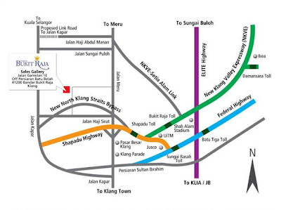
Map to Bandar Bukit Raja_New


Here is the new map to Bandar Bukit Raja, Klang, Selangor. It will be useful to outstation people.


Car park not in the porch but outside.


Funny people at Bandar Bukit Raja, they park their car outside but left the porch empty.


Sunday, March 29, 2009

Pergola_Installation completed.

Well the pergola with skylight is ready, but then photo will be posted later.

Sunday, March 22, 2009

Shifted To Bandar Bukit Raja_yesterday

Shifted to Bandar Bukit Raja finally. Will post foto of my new home when I'm not so busy.

Thursday, March 12, 2009

Shift House or rather Aquarium

The 'Ikan Naga" in their new home in Bandar Bukit Raja.

Wednesday, March 11, 2009

Aquarium_Introducing Polypterus Ornatipinnis

Polypterus Ornatipinnis still in the plastic bag,place in the aquarium
for thirty minutes for the temperature in the plastic bag and aquarium
to normalize before releasing the fish in the aquarium.
The fish is already released in the aquarium.


Friday, March 6, 2009

Installation of Wardrobe completed.


Installation of wardrobe started yesterday and completed today.


MG Room

MY ROOM


Thursday, March 5, 2009

Installatin of Panasonic Fan, AirCon and reinstallation of Kitchen Cabinet.


Installation of Panasonic Fan on Friday 27 Feb 2009


Old design entrance to Dinning/Kitchen.

New entrance design to Dinning/Kitchen.
(Old design please see above.)

Reinstalltion of Kitchen Cabinet on Monday 02 March 2009

Mr. Osman of Farouk Renovation (h/p: 0163680339)

My painter Mr. Yanto (h/p: 0166039255)

Kitchen extension.


Panasonic 1.5 HP Inverter AirCon


Tuesday, February 24, 2009

Bandar Bukit Raja_Map

Entrance to Bandar Bukit Raja


Corner lot of Lotus.

Map to Bandar Bukit Raja.